

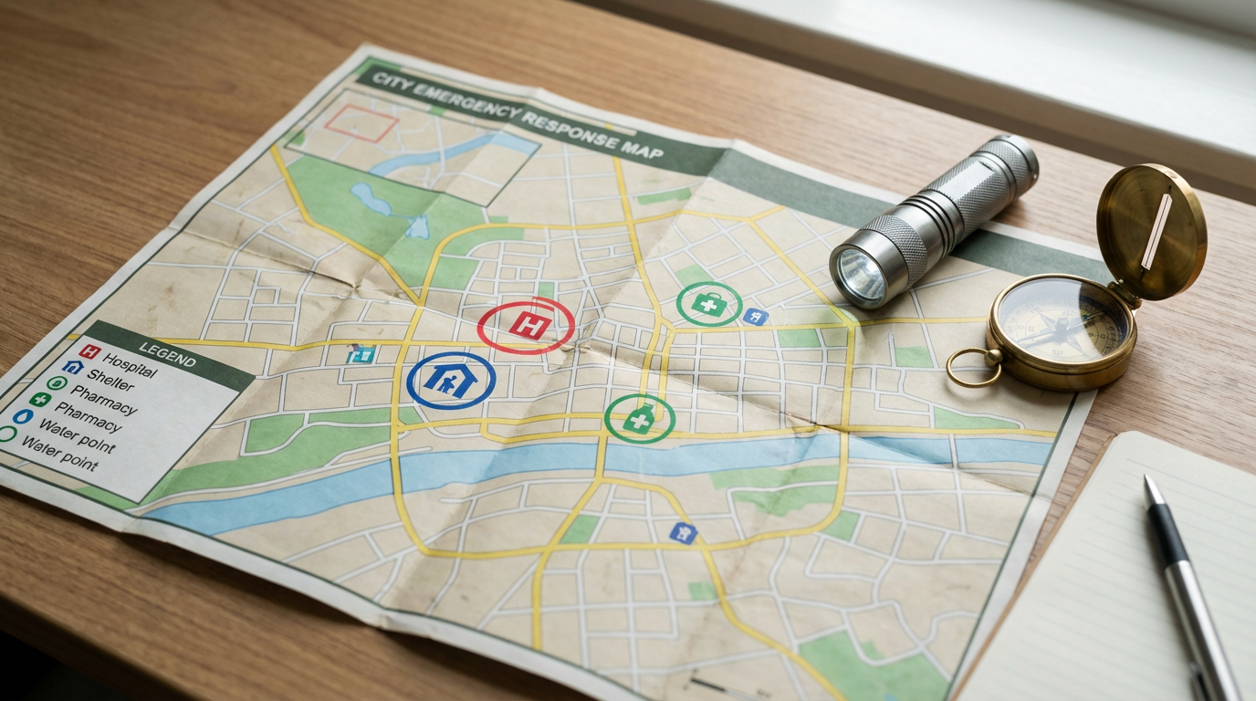
When disaster hits, having quick access to emergency resources is key. Now, an interactive map gives you vital info right at your fingertips. It shows where shelters, supply stores, and emergency services are, so you’re never far from help when you need it.
The U.S. Geological Survey (USGS) is a big help, offering real-time data from over 11,000 streamgages and watching 169 active volcanoes. They also provide critical info before hurricanes hit and check risks after wildfires. This info helps make the interactive map a top tool for getting ready for disasters.
The 2-1-1 Texas helpline is there for you 24/7, 365 days a year. It’s a free service that links people with emergency resources. In California, the Office of Access and Functional Needs (OAFN) makes sure people with disabilities are part of emergency plans. They offer special help like the Disaster Response Interpreter program.
Key Takeaways
- Interactive maps provide quick access to local emergency resources
- USGS monitors over 11,000 streamgages and 169 active volcanoes
- 2-1-1 Texas offers 24/7 helpline for emergency assistance
- California’s OAFN ensures inclusive disaster preparedness
- Real-time data enhances community safety during emergencies
- Disaster Response Interpreter program supports accessibility
- GIS web maps improve whole community planning efforts
Understanding the Importance of Local Emergency Resources
Local emergency resources are key to keeping communities safe. They are vital for managing responses and recoveries after disasters. These resources tackle emergencies like natural disasters and health crises.
The Role of Emergency Resources in Community Safety
Local governments lead in emergency management. Their aim is to fix essential services and aid communities in recovering. They provide immediate help with water, food, and medical care. They also fix damaged buildings and offer counseling.
How Interactive Maps Enhance Disaster Preparedness
An emergency services map is a crucial tool for getting ready for disasters. It shows where to find shelters, supply stores, and emergency help. This interactive map helps people find the help they need fast during emergencies.
Types of Emergencies Covered by Local Resources
Local emergency resources are ready for many emergencies. These include:
- Natural disasters (floods, hurricanes, earthquakes)
- Power outages
- Health crises
- Fire emergencies
- Severe weather events
| Emergency Type | Response Time | Key Resources |
|---|---|---|
| Natural Disasters | Immediate to Long-term | Shelters, Emergency Supplies, Rescue Teams |
| Power Outages | Hours to Days | Utility Companies, Backup Generators |
| Health Crises | Ongoing | Hospitals, Medical Supplies, Vaccination Centers |
| Fire Emergencies | Minutes | Fire Departments, Water Resources |
| Severe Weather | Hours to Days | Weather Alerts, Safe Zones |
By knowing and using these resources, communities can boost their disaster readiness and response.
Navigating the Interactive Emergency Map Interface
The interactive emergency map interface is a key tool for finding important resources during emergencies. It makes it easy to locate local shelters and emergency supply stores. This platform is user-friendly and efficient.
With GIS technology, the map shows exact locations of critical services. You can use it on web browsers or mobile devices. This ensures you have the info you need when it’s most important.
The interface is made for easy use:
- Zoom in and out to view different areas
- Click on icons to get details about specific locations
- Use the search function to find resources near you
- Toggle layers to display different types of emergency services
In 2023, HEARTsafe Eugene Springfield used a similar mapping system. They registered 406 AEDs across the city. This shows how digital tools can boost community safety.
Knowing how to use the emergency map before an emergency can save time. Take a moment to check out its features. Bookmark the site for quick access in emergencies.
Locating Emergency Shelters and Safe Spaces
When disaster hits, finding emergency shelters and safe places is key. Modern tech, like GIS capabilities, has changed how we find these important spots. Let’s look at how to find shelter in emergencies and the options you have.
Shelter Location Using GIS
GIS tech helps us pinpoint shelter locations accurately. It lets emergency teams quickly map out safe areas. You can get shelter info by texting your ZIP code to 43362, which shows addresses up to 200 miles away.
Types of Emergency Shelters
Not all emergencies need the same type of shelter. On average, emergency teams give advice for 5 different kinds of emergencies. These include:
- General population shelters
- Special needs shelters
- Pet-friendly shelters (47% accommodate pets)
- In-place sheltering (74% of emergencies require staying put)
- Vehicle sheltering (69% say it’s safer than driving in certain emergencies)
Accessing Shelter Information
Getting to shelter info fast is crucial in emergencies. Here’s how to find it:
- Text your ZIP code to 43362 for nearby shelter locations
- Use emergency management apps with GIS capabilities
- Listen to local radio for updates (43% say car radios have minimal battery impact)
- Check official social media channels
Remember, 63% of people are told to bring emergency supplies when going to shelter. Once there, 82% are told to find a safe spot based on the emergency type. Stay informed and ready to keep safe during tough times.
Identifying Local Emergency Supply Stores
The interactive map makes it easy to find emergency supply stores near you. These stores have all the disaster preparedness supplies you might need. Whether it’s for natural disasters or power outages, they have you covered.
Emergency supply stores carry a wide variety of items. You can find generators, water purification systems, and non-perishable food. They also offer advice on picking the right supplies for your situation.
When you visit these stores, think about getting these key items:
- Functional fire extinguisher
- Carbon monoxide detector
- First aid kit
- Battery-powered or hand-crank radio
- Flashlights and extra batteries
Being prepared is key. Many people think they’re ready for emergencies, but they’re not. By checking out emergency supply stores, you’re taking a big step towards being truly prepared.
Local governments often find it hard to stress the need for disaster preparedness. That’s why these stores are so important. They give you the supplies and the info you need for emergency planning.
Use the interactive map to find emergency supply stores near you. Stock up on the essentials today. Don’t wait for a crisis to hit – be ready for anything.
Accessing Power Outage Information and Updates
Power outages can really disrupt our daily lives. They affect everything from how we store food to the use of medical devices. It’s important to stay informed about these outages for safety and planning. Let’s look at how to get the latest power outage info and be ready.
Understanding ERCOT Grid Information
The Electric Reliability Council of Texas (ERCOT) manages the power grid for most of Texas. You can get real-time updates on the ERCOT grid at their website. This info helps you see the current power supply and demand across the state.
Using the Public Utility Commission Outage Map
The Public Utility Commission of Texas has an outage map on their website. This map shows power outages across the state. It’s a great tool for seeing the extent and how long outages will last in your area.
Tips for Power Outage Safety
When there’s a power outage, safety comes first. Here are some important tips:
- Keep your freezer closed. A full freezer can keep its temperature for up to 48 hours.
- Use generators outdoors only, at least 20 feet away from windows to prevent carbon monoxide poisoning.
- Unplug appliances to prevent damage from power surges.
- Have a battery-operated radio for updates, especially during severe weather.
- Prepare an emergency kit with essentials like flashlights, batteries, and non-perishable food.
| Item | Duration |
|---|---|
| Full Freezer | Up to 48 hours |
| Half-Full Freezer | Up to 24 hours |
| Refrigerator | About 4 hours |
Being informed and prepared is crucial during power outages. Use these resources and tips to keep you and your family safe.
Finding Medical Facilities and Healthcare Resources

Finding medical help quickly is key in emergencies. The interactive map shows where hospitals, urgent care, and other healthcare services are. This is super helpful when you need medical care fast.
Emergency services are easy to find on the map. You can see where ambulances, fire stations, and police are. This is great for getting help right away in an emergency.
The map also lists mental health resources. The Substance Abuse and Mental Health Services Administration (SAMHSA) Disaster Distress Helpline is open 24/7 at 1-800-985-5990. It gives crisis counseling for those feeling emotional stress from disasters or emergencies.
Older adults can get emotional support from the Friendship Line California at 1-888-670-1360. This service offers crisis intervention and support calls just for seniors.
| Healthcare Resource | Contact Information | Services Provided |
|---|---|---|
| SAMHSA Disaster Distress Helpline | 1-800-985-5990 | 24/7 crisis counseling |
| Friendship Line California | 1-888-670-1360 | Emotional support for older adults |
| Medicare Assistance | 1-800-MEDICARE | 24/7 live chat support |
| CalHOPE Warm Line | 1-833-317-HOPE (4673) | Peer counseling for COVID-19 related stress |
The interactive map is a great tool for getting ready for disasters. It shows where emergency shelters, medical places, and healthcare resources are. With this info, communities can handle crises better and keep everyone safe.
Disaster Assistance Programs and Services
When disaster hits, knowing where to get help is key. FEMA and other groups offer crucial support to those hit by disasters. Let’s look at the disaster assistance programs available to help communities in need.
FEMA Individual Assistance Program Overview
FEMA has changed how it helps after disasters. Starting March 22, 2024, it made big updates to support survivors better. These updates include flexible funding, wider eligibility, and an easier application process.
The Individuals and Households Program (IHP) gives financial help and direct services for uninsured or underinsured costs. FEMA might check your home or contact you to verify your info.
State-Specific Disaster Relief Resources
Each state has its own disaster relief. For example, Texas has its Department of Emergency Management to lead local efforts. These state programs work with federal help to give full support.
Non-Profit and Faith-Based Organization Support
Non-profits and faith-based groups are key in disaster recovery. They offer quick help like emergency shelter, food, and medical aid. These groups fill in where government support is lacking and give personal help to communities hit hard.
| Program | Purpose | Eligible Beneficiaries |
|---|---|---|
| Livestock Forage Disaster Program | Compensates for grazing losses | Eligible producers |
| Livestock Indemnity Program | Benefits for livestock deaths | Producers with excessive losses |
| Emergency Assistance Program | Aids livestock, honeybee, fish producers | Producers with specific losses |
| Emergency Loan Program | Helps recover from production losses | Disaster-affected producers |
These programs, along with others like the Noninsured Disaster Assistance Program and Tree Assistance Program, make up a wide network of support for those hit by disasters.
Local Emergency Resources for Weather-Related Disasters
California faces many weather disasters, like heatwaves and severe storms. Our map shows important emergency resources to keep you safe.
Heatwaves in California can get very hot. Places inland may see temperatures over 120 degrees, especially near Death Valley. During these times, shelters offer cool places for those at risk.
Winter storms also pose challenges. The 2024 Winter Storm plan in California is ready for power outages, flooding, and more. You can find real-time updates on these issues.
Listos California helped nearly 4 million people at risk from 2019-2021. It connects folks with key emergency resources.
| Emergency Resource | Service Provided | Availability |
|---|---|---|
| 2-1-1 Service | Emergency Information | 100% of California counties |
| FEMA App | Shelter Locations | Statewide |
| Nixle Alerts | Real-time Notifications | Based on zip code |
| Save Our Water | Water Conservation Tips | Statewide |
The Disability Disaster Access and Resource Program (DDAR) helps people who need electricity for health. It gives aid with medical devices during power outages.
Being prepared is crucial. Use these local emergency resources to stay informed and safe during weather disasters.
Legal Aid and Insurance Information for Disaster Victims
When disaster hits, victims face many legal and insurance challenges. In the U.S., 248 major natural disasters have been declared since 2013. It’s vital to know about legal aid and insurance help during recovery.
Accessing free legal resources post-disaster
The Disaster Legal Services (DLS) program gives free legal help to those who can’t afford it. This service is under the Robert T. Stafford Disaster Relief and Emergency Assistance Act. Volunteer lawyers offer advice on insurance claims, help with lost legal papers, and assist with FEMA appeals.
Understanding insurance claims and coverage
Insurance claims can be tough, especially after big events like Hurricanes Harvey, Maria, and Irma. Knowing your coverage, like wind and flood insurance, is key. Legal aid can guide you through your policies and the claims process. This ensures you get the compensation you deserve.
Avoiding contractor scams during recovery
Scammers often appear after disasters. Be cautious of contractors who want upfront payments or rush you to sign contracts. Legal aid services can review contracts and explain your rights. Being informed is your best way to fight fraud during disaster recovery.
Source Links
- https://www.usgs.gov/programs/emergency-management/emergency-management-resources
- https://www.caloes.ca.gov/office-of-the-director/policy-administration/access-functional-needs/
- https://training.fema.gov/emiweb/downloads/is7unit_2.pdf
- http://gtcountymi.gov/369/What-Is-a-Local-Emergency
- https://securitytoday.com/articles/2021/11/15/navigating-emergency-response.aspx
- https://www.pulsepoint.org/
- https://emergency.cdc.gov/shelterinplace.asp
- https://www.salvationarmyusa.org/usn/emergency-shelters/
- https://www.fema.gov/emergency-managers/national-preparedness/plan
- https://www.civicplus.com/blog/ps/local-government-community-emergency-preparedness/
- https://www.ready.gov/power-outages
- https://www.redcross.org/get-help/how-to-prepare-for-emergencies/types-of-emergencies/power-outage.html
- https://bkvenergy.com/blog/what-to-do-when-your-power-goes-out/
- https://bphc.hrsa.gov/technical-assistance/emergency-preparedness-response-recovery-resources-health-centers
- https://www.chhs.ca.gov/blog/2023/01/04/calhhs-emergency-resource-guide/
- https://emsa.ca.gov/disaster-medical-services-division-links/
- https://www.fema.gov/assistance/individual
- https://fsa.usda.gov/programs-and-services/disaster-assistance-program/index
- https://www.dor.ca.gov/Home/disasterpreparedness
- https://www.caassistedliving.org/CALA/Member_Resources/Emergency_Preparedness/Emergency_Preparedness_Web_Resources.aspx
- https://www.lsc.gov/initiatives/lsc-task-forces/lsc-disaster-task-force
- https://www.fema.gov/fact-sheet/disaster-legal-services